Live Cams
Countries
Featured Cams
Get A Cam
Live Cams
Countries
Featured Cams
Get A Cam
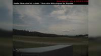
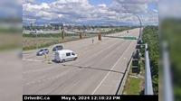
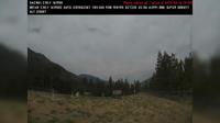
Wells › West: Hwy 26, near - about 78 km east of Quesnel, looking west | Live Webcams
Webcam & Weather Report
See.cam
North America
CA
British Columbia
Wells
Wells › West: Hwy 26, near - about 78 km east of Quesnel, looking west
Current Still
Timelapse
Daylight Still
Webcam was last updated 1 years ago
Rating
Webcam Views
Map
Discuss
See more webcams in
British Columbia
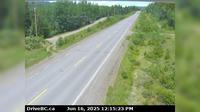
Salmon Arm › South-East: SalmonArm
Grassy Plains › West: Hwy 35 at Francois Lake Southbank Ferry Landing looking north at ferry ramp
Little Fort › North: Hwy 5, in - at Hwy 5/Hwy 24 junction, looking north
Abbotsford › South: Hwy 1 at Clearbrook Rd, looking south
Delta › East: Hwy 17 at Salish Sea Drive (48th Street), looking east
Pitt Meadows › North-West: Pitt River Bridge
Area B
North Vancouver › North: Hwy 1 (Upper Levels Highway) at Lonsdale Ave, looking north
Area L
Lytton › North-West
Burns Lake › North: Hwy 35, near Martin Road midway between - and the northern Francois Ferry Landing, looking north
Revelstoke › North-West
Explore by Continent
Europe
Asia
South America
Oceania
North America
Africa


Discuss