Live Cams
Countries
Featured Cams
Get A Cam
Live Cams
Countries
Featured Cams
Get A Cam
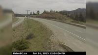
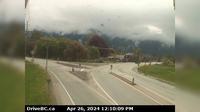
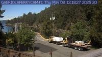
Peace River Regional District › South: Hwy 97 at Beaton Highway, 44 km north of Fort St. John, looking south | Live Webcams
Webcam & Weather Report
See.cam
North America
CA
British Columbia
Taylor
Peace River Regional District › South: Hwy 97 at Beaton Highway, 44 km north of Fort St. John, looking south
Current Still
Timelapse
Daylight Still
Webcam was last updated 1 years ago
Rating
Webcam Views
Map
Discuss
See more webcams in
British Columbia
Avola › North: Hwy 5, about 20 km south of Blue River and 19 km north of - looking north
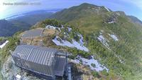
Area C: Mount Arrowsmith
Thompson-Nicola Regional District › North: , Hwy at Larson Hill, km south of Merritt, looking north
Hope 1 › West: Hwy 1 at Hwy 7 near Hope, looking west
Area C
Pacific Sands Beach
Kelowna › South-West
Rural Municipality of Brackley › South-West: New Haven
Kent › East: Hwy 7 at Hwy 9 (Evergreen Drive) in Agassiz, looking east
Port Edward › East: Hwy 16, next to the Skeena River, about 70 KM east of Prince Rupert, looking east
District of North Vancouver › South: Hwy 1 (Upper Levels Highway) at Capilano Rd. looking south
Area B › North-West: Ferry
Explore by Continent
Europe
Asia
South America
Oceania
North America
Africa


Discuss