Live Cams
Countries
Featured Cams
Get A Cam
Live Cams
Countries
Featured Cams
Get A Cam
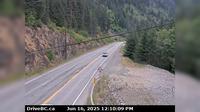
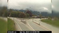
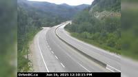
Columbia-Shuswap Regional District › West: , Hwy , by Griffin Lake, about km west of Revelstoke, looking west | Live Webcams
Webcam & Weather Report
See.cam
North America
CA
British Columbia
Taft
Columbia-Shuswap Regional District › West: , Hwy , by Griffin Lake, about km west of Revelstoke, looking west
Current Still
Timelapse
Daylight Still
Webcam was last updated 5 years ago
Rating
Webcam Views
Map
Discuss
See more webcams in
British Columbia
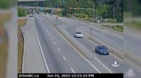
Surrey › North: Hwy 1 at 176th Street overpass, looking north
Boston Bar › South: Hwy 1 at Bradley Hill, about 3.5 km south of Hells Gate, looking south
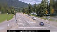
Playmor Junction › North: Hwy 6 at Hwy 3A in - looking north
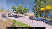
Area K › East: Hwy 6 at Needles Ferry Landing, looking east towards front of line up near the rest area
Kent › East: Hwy 7 at Hwy 9 (Evergreen Drive) in Agassiz, looking east
Spaxomin › North: Hwy 5, 24 km north of Merritt at Helmer Interchange, looking north
Surrey › East: Hwy 10 at 152<sup>nd</sup> Street, looking east on Hwy
Taylor › North: Hwy 97 at Pine Avenue in - looking north
Area B › South: Hwy 5, by northbound Portia Chain Up, looking south
Area D › North
Golf Club 1st hole
Salmon Arm › South: Hwy 1 at 30th Street SW in - looking south
Explore by Continent
Europe
Asia
South America
Oceania
North America
Africa


Discuss