Live Cams
Countries
Featured Cams
Get A Cam
Live Cams
Countries
Featured Cams
Get A Cam
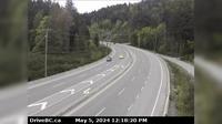
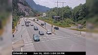
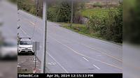
Summerland › South: Hwy 97 at Callan Rd, about 6 km north of - about 15 km south of Peachland. Looking south | Live Webcams
Webcam & Weather Report
See.cam
North America
CA
British Columbia
Summerland
Summerland › South: Hwy 97 at Callan Rd, about 6 km north of - about 15 km south of Peachland. Looking south
Current Still
Timelapse
Daylight Still
Webcam was last updated 1 years ago
Rating
Webcam Views
Map
Discuss
See more webcams in
British Columbia
Juan de Fuca Electoral Area › South: Hwy 1 at Okotoks Road, looking south
Central Saanich › West: Hwy 17 at Mt Newton Cross Rd, looking west
Columbia-Shuswap Regional District › East: , Hwy , about km north of Golden at Donald Bridge, looking east
Thompson-Nicola Regional District › South: Hwy 5, approximately 40 km north of Blue River, looking south
Area A › South: Hwy 95, near Quinn Creek, about 31 km north of Brisco, looking south
Northridge › South: Hwy 99 at Valley Drive, looking south
Gitwinksihlkw › North-East: Hwy 113 at Anlaw Rd, near - within Nisga'a Memorial Lava Bed Provincial Park, looking east
Qualicum Beach › West: Hwy 19, south of Qualicum Interchange at Hwy 4, looking west
Surrey › North-West: Hwy 15 at Fraser Hwy (1A) looking north-west
Pitt Meadows › North: Hwy 7 (Lougheed Hwy) at Harris Road, looking north
Great Central › North-West: PortAlberni
New Westminster › South: Pattullo Bridge at north end, in - looking south
Explore by Continent
Europe
Asia
South America
Oceania
North America
Africa


Discuss