Live Cams
Countries
Featured Cams
Get A Cam
Live Cams
Countries
Featured Cams
Get A Cam
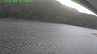
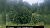
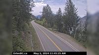
Area E › North: Hwy 33, about 14 km north of Westbridge and 20 km south of Beaverdell, looking north | Live Webcams
Webcam & Weather Report
See.cam
North America
CA
British Columbia
Area E
Area E › North: Hwy 33, about 14 km north of Westbridge and 20 km south of Beaverdell, looking north
Current Still
Timelapse
Daylight Still
Webcam was last updated 1 years ago
Rating
Webcam Views
Map
Discuss
See more webcams in
British Columbia
Area A
Chetwynd
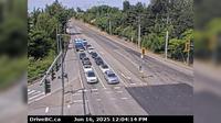
Marketplace › North: Hwy 99, in Whistler at Lorimer Rd, looking north
Delta › North: Hwy 17 (South Fraser Perimeter Rd) at Deltaport Way in South - looking north
City of Langley › West: Hwy 10 at 192 Street, looking west
Salmon Arm › South-East: SalmonArm
Harrison Hot Springs › West: Hwy 1 at Herrling Island overpass westbound, looking west
Fauquier › East: Hwy 6 at - Ferry Landing, looking east
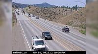
Kamloops › West: Hwy 1 at Peterson Creek bridge in - looking west
Regional District of Central Kootenay › South: Hwy A near Sanca Creek, . km south of Sanca Creek Bridge, looking south
Duncan › North: Hwy 1 in - at Trunk Rd, looking north
Haney › East: Northbound on Kanaka Way at Lougheed Highway
Explore by Continent
Europe
Asia
South America
Oceania
North America
Africa


Discuss