Live Cams
Countries
Featured Cams
Get A Cam
Live Cams
Countries
Featured Cams
Get A Cam
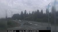
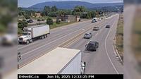
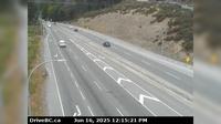
Area B › North: Hwy 23, about 30 km south of Revelstoke and 22 km north of Shelter Bay Ferry, looking north | Live Webcams
Webcam & Weather Report
See.cam
North America
CA
British Columbia
Area B
Area B › North: Hwy 23, about 30 km south of Revelstoke and 22 km north of Shelter Bay Ferry, looking north
Current Still
Timelapse
Daylight Still
Webcam was last updated 1 years ago
Rating
Webcam Views
Map
Discuss
See more webcams in
British Columbia
Cobble Hill › South: Hwy 1 at Cowichan Bay Rd - Rd, looking south
Saanich › South: Hwy 17 southbound (Blanshard St) at - Rd, looking south
Mary Hill › North: Hwy 7B - Bypass), at Broadway St in Port Coquitlam, looking north
Regional District of Bulkley-Nechako: Burns Lake Airport W
Salmon Arm › East: Hwy 1 at 30th Street SW in - looking east
Delta › East: Hwy 91 Connector at Nordel Way, looking east
Pemberton › East: Hwy 99 at Portage Rd in - looking east
Columbia-Shuswap Regional District › West: , Hwy , about km north of Golden at Donald Bridge, looking west
Langford › North: Hwy 1 at West Shore Parkway, looking northbound toward Goldstream Park
City of Langley › East: Hwy 10 at 192 Street, looking east
Barriere › South: Hwy 5 at Agate Bay Rd, south of - looking south
Bridgeview › West: Pattullo Bridge at the south end, in Surrey, looking west
Explore by Continent
Europe
Asia
South America
Oceania
North America
Africa


Discuss